The cost of performing 3D laser scanning is largely based on the area of the scan needed and the proximity of the job site to the location of the scanning technician. But ensuring a complete and accurate estimate of the scanning effort usually requires additional information.
Here are the relevant topics that should be addressed by your scanning professional before estimating a fee for 3D laser scanning services.
More than a Data Point Cloud: How the Data is Used
Just as engineering is more than providing construction drawings, three-dimensional scanning is more than just providing a data point cloud. The scanning consultant should not be a one-dimensional solution provider. Although the data point cloud can be considered a commodity to be purchased at the lowest cost, there is a significant value-add from engineering consultants who can integrate the 3D scan with the proposed new work.
The value of 3D laser scanning lies in how the data is used after the scan. If a data point cloud is used only as an image of the proposed work area, the advantages of laser scanning have been lost. Once again, if your laser scanning consultant does not integrate an engineering solution directly into the point cloud, then the technology has not been used to its greatest advantage.
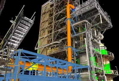
Proposed Refractory-lined Duct Routed to Refinery FCC Unit
When an engineering services provider proposes a 3D scanning solution, it’s important to have a pre-proposal discussion so the consultant and customer better understand the project size, complexities, and project boundaries. It is also helpful to this discussion to have existing drawings or photographs of the work area available for reference.
Following are some of the common topics that may be discussed during the initial conversation between the scanning consultant and the customer.
10 Questions to Define Project Purpose
Understanding the purpose of the 3D laser scanning project will set the tone for additional conversation related to the project. Several common questions are:
- Is the 3D scanning to be used to as-built an existing process or facility?
- Is the 3D scanning needed for a future project where the scope is still being defined?
- How large is the area to be scanned?
- Is an existing process or structure being modified?
- Are there specific interest points, such as tie-points or other critical information, that need to be captured?
- What level of detail is required for the 3D scan?
- Is the area to be scanned electrically classified?
- Is the work inside or outside?
- Does information related to exterior building walls or elements located above the roof need to be captured by the 3D scan?
- Are there multiple levels that require scanning?
Point Cloud Usage
The most important reason for 3D laser scanning is to collect data on the existing process or facility.
There can be significant advantages to having the Engineer of Record provide scanning services rather than “scanning only” companies. The engineer can integrate the proposed design directly into the point cloud to create an augmented reality model showing existing information and new work sharing the same space.
As the project develops, the 3D model/point cloud is very useful for coordination and communication between the engineer and owner. Once the model is developed, plan and elevation drawings can be automatically created, with annotation of the drawings to be completed by a designer.
Boundaries of Work
Existing drawings and photos of the project site can be very helpful in understanding the general size and complexity associated with the scan. These documents can be used to better determine the level of difficulty in moving the scanning instrument around existing plant equipment, utilities, and other obstructions. General obstructions include line-of-sight limitations due to tall equipment or stored materials, congested spaces, stairways connecting multiple levels, or multiple smaller rooms.
Since scanning effort is directly related to the area of the scan, providing a drawing or sketch that includes overall dimensional information of the area is needed to determine the duration of the scanning procedure. The time required to scan a project is directly related to the fee for the scanning service.
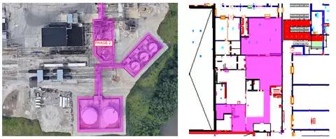
Examples Showing Highlighted Areas to be Scanned
Access Requirements
Access limitations can also play an important role in estimating the time required to perform scanning. Multilevel processes and highly congested areas can add significant time to scanning. Areas that are difficult to reach, including elevated areas accessible via ladder only, can complicate the scanning effort. For safety reasons, Matrix Technologies prefers to scan areas that are accessible via stairways.
Highly congested areas, including heavy process and mechanical areas, can also add time to the scanning effort. Since the scanner is based on line-of-sight technology, congested areas will require additional scans to fully develop the point cloud.
Environmental Factors
Interior facility scanning generally can be performed with little regard to environmental factors and their effect on the scanning efficiency and quality of data collected.
However, the efficiency of outdoor scanning can be heavily weather-dependent. Modern scanning equipment can be rated for water intrusion, but scanning during a rain event will produce undesirable amounts of noise in the data. Scanning during snow events has the same effect. Other process conditions, including steam plumes, can affect the efficiency and quality of data collected on site. When scanning outside, it is critical to understand the environmental conditions, including weather and process emissions prior to starting work.
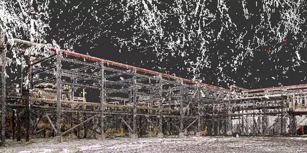
Point Cloud Noise Caused by Snowfall
Lighting
Since the laser scanner operates on laser technology, the point cloud is unaffected by lighting conditions. However, the active 70-megapixel color pictures that are generally provided with the point cloud as a deliverable are affected by lighting conditions.
To provide quality photos, it is important to provide sufficient lighting. Exterior scanning is generally limited to daylight hours, which can vary greatly between summer and winter months.
In cases where photos are not needed, scanning times are decreased, which reduces data collection time in the field.
Survey Control
Some facilities require an established local coordinate control system. This helps ensure that all firms and parties performing work at that facility locate items such as foundations and buildings using the same geometric basis or control. By tying the laser scan into these existing control systems, the data can be easily communicated to construction contractors and engineers.
Survey control is established by using surveyor benchmarks and monuments to assist in tying the scanning point cloud into a known control system. If a facility requires that a point cloud be tied into existing control, the scanning technician will require additional time to determine the location of the survey monuments and traverse the scan from the monument to the area to be scanned. In some cases, a survey crew may be required to extend survey control to the area of interest if existing benchmarks are located a large distance away from the area to be scanned.
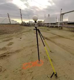
Tying Point Cloud to Existing Survey Control
Matrix Technologies is one of the largest independent process design, industrial automation engineering, and manufacturing operations management companies in North America. To learn more about our 3D laser scanning services and multidiscipline engineering solutions, contact Mark O’Connell, PE, Associate Director of Capital Project Planning.
Click here to read Part 1: Using 3D Laser Scanning in Industrial Plant Design
Click here to read Part 2: Crucial Benefit Drivers
© Matrix Technologies, Inc.